Muela de Utiel
Impressive mountain with several viewpoints overlooking the Tagus

Muela de Utiel
Dirección
Muela de Utiel
GPS
40.622583665785, -1.9354911608021
Muela de Utiel
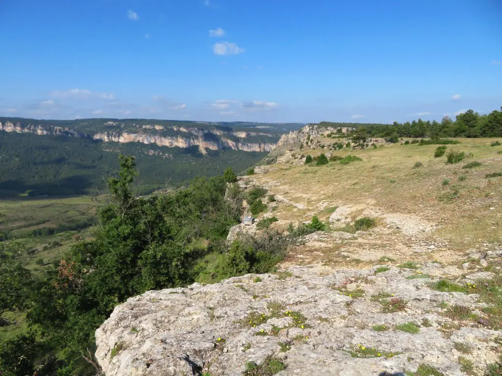
The Muela de Utiel at 1505 metres, is an extensive plateau (around 3000 ha), covered with pine forests, which rises up between the courses of the Tagus and its tributary the Cabrillas, within the limits of the Upper Tagus Natural Park. It constitutes a important karst area (Karst de la Muela de Utiel and Hoz Seca), where the most developed cavity in the province of Guadalajara and the entire central peninsular (Tornero CaveThe Sima del Bochorno, about 20 km of galleries) and one of the deepest (Sima del Bochorno, -149 m).
On the edges there are a series of discreet tree-free prows or hills, which make good viewpoints over the ravines and rocky outcrops that characterise this natural area; the Mirador de Pie Molino, which dominates the lands of Peralejos de las Truchas from above, and the Mirador del Machorrillo, to the west, over the folds where the Taravilla Lagoon o de la Parra. At the north-western end of the muela, separated from its matrix by the Somero pass (1279 m), we can identify the vigorous relief of the Muela del Conde.
It is possible to walk along the local footpath (SL-06 "Mirador de Pie Molino" or SL-07 "El Escalerón y el Río Tajo"), which climbs up to the millstone from the centre of the village itself. Peralejos de las TruchasWe don't know how the markings are at the moment, so it would be advisable to download the track or see our description of the route. Another possibility to go through this area is to use the Route 4 "La MuelaThe Alto Tajo Natural Park, which will take us through its various viewpoints.
The geology associated with this area (together with the climate) will determine the landscape we will see in these areas, and there will be karst canyons, chasms... all with a predominantly wooded vegetation, the forest on the slopes being thicker and more productive. The fertility of these lands meant that they were exploited in the past, so when descending to Peralejos on the route SL-6 Mirador del Pie Molino we can see a large number of terraces on the hillside, as well as deforested areas in the forest on the route SL-8, Sacea, Los Blancos and El Chaparral.
<< A bit of geology
La Muela Utiel is a fundamentally Cretaceous mountain isolated by the denudation of the fluvial network on the peneplain formed in the Tertiary. The Lower Cretaceous is formed mainly by sands and clays, making it easily eroded land and forming slopes, generally gently sloping, under the protection of the hard rocks of the Upper Cretaceous.
These are quite fertile lands that give rise to thick forests and green pastures. The overlying rocks are from the Upper Cretaceous and among them the Ciudad Encantada Dolomite formation stands out, as it is formed by hard limestone in banks up to 100 metres thick that give rise to strong topographical projections, with large vertical escarpments and even overhangs. This stratigraphic configuration gives La Muela de Utiel the appearance of an enormous castle, with gentle slopes at the bottom of the valley, which become steeper and steeper until they reach verticality and thus isolate it.
This structure is divided into two sectors by a fault running NNW to SSE, the eastern one being the sunken block. In the eastern part of the fault, the strata are almost horizontally disposed, and the crust is almost flat, with very few superficial valleys. Instead, there are some small torcas and dolines, together with chasms, which are responsible for draining the precipitated water. The western part, the raised block, shows some gentle folds, together with a tilting towards the west.
This means that this block has more ravines (some of them quite deep) that dissect the muela in an east-west direction. The whole of the muela is a beautiful example of internal karst with abundant chasms, caves, some dolines and an important network of ravines and canyons with springs that drain the water, so do not forget to take extreme precautions when travelling through this type of landscape.

