Celtiberian Hillfort El Ceremeño
Celtiberian settlement with 2 epochs of occupation

The Ceremeño
Dirección
Celtiberian Hillfort El Ceremeño
GPS
40.886406, -1.966034
Celtiberian Hillfort El Ceremeño
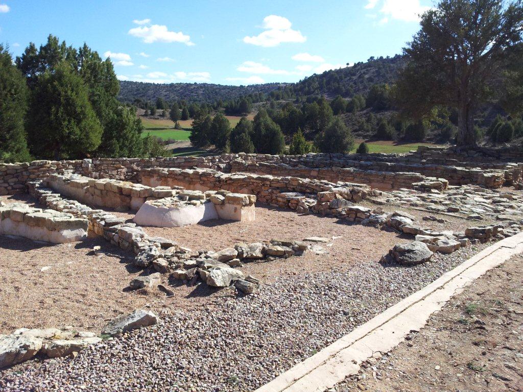
The Celtiberian Hillfort of El Ceremeño is a small Celtiberian settlement strategically located on a witness hill to the 1,067 metres altitude control system that controls the elderflower valleywhich eventually discharges its waters into the Gallo river.
Retains the defensive and domestic structures in two villages successive stages that can be seen with the naked eye. The firstdating back to the VI BC.was destroyed by fire and a new building was erected on its remains. second settlement, until the abandonment of the site around the turn of the century. IV BC This feature is one of the most remarkable since rarely, we can see these two occupation processes so clearly.
Numerous studies have been carried out to investigate this settlement in an attempt to answer many questions, and thanks to this exhaustive research, it has been possible to uncover the necropolis of Herrería with some tombs without urns and others, marked with stelae and stone tumuli whose most modern level is coeval with the oldest phase of the settlement.
THE SETTLEMENT AND ITS PHASES
The defensive and domestic structures of the two successive settlements have been preserved. The first served as a base for a second settlement to be built on its remains until it was finally abandoned.
THE DEFENSIVE SYSTEM
The occupants of El Ceremeño, in order to reinforce their natural position, initially constructed a powerful limestone walladapted to the topographical characteristics of the terrain, which would have reinforced the entire perimeter of the settlement, although it has been better preserved on the west and south sides, which have been restored and refurbished.
The width of the wall is approximately 2-2.5 metres and some 65 metres long (35 on the west side and 30 on the south side). The southern section is not straight, but has a sharp bend towards the outside (to adapt to the terrain and provide better visual control). In turn, the section on the west side has a bend or projection that would allow better control over this area of the wall.
During the second period of occupation, this wall was reinforced by the construction of a rectangular tower (6 by 4 m) at the angle of the junction of the two walled sections, built inwards instead of protruding outwards. This elevation served as a vantage point to observe the surroundings and to control the south side, up to the gateway to the settlement, while the west side was completed with the elbow, to which two buttresses were added, to achieve complete visual control of the valley.
THE INTERIOR SPACE
The interior of the building contains the housing units, rectangular and attached to each otherThey follow the "central street" model, which was common in many Iron Age settlements. They consist of two or three interior rooms: the vestibule, the large central room where the hearth was located and the pantry at the back where provisions were kept.
In the lower level, which corresponds to the oldest settlement, it has been possible to differentiate between nine dwellingsThe houses are arranged in a pattern that follows the characteristic "central street" model. Five of these houses are attached to each other and aligned along the south wall with the door facing the interior street, while two of them lean their back against the west wall and their doors face the interior space, their size varying from 35 and 50 m2.
The second village is structured, maintaining the model of "central street", The space was separated by a wall, set in an east-west direction. The following were created two neighbourhoods Each of them consists of two rows of houses, one of which rests on the back of the corresponding section of wall (north or south) and the other rests on the back of the central wall. It has been possible to delimit 28 dwellings (of which only 9 have been excavated) with a rectangular ground plan and almost identical dimensions. between 17 and 19 m2smaller than those of the old phase
THE NECROPOLIS (NOT OPEN TO VISITORS)
The interesting information provided by the village has been complemented by the discovery of the necropolis (1997) near the castro, next to the village of Herrería, on the plain, but on the other side, on the left bank of the river.
The following have been documented four phases of burials overlapping, but, apparently, only one of these corresponds to the people who occupied the settlement.. They practised the rite of cremating the corpses with their personal belongings, burying the remains of the incineration in a hole in the ground, differentiating some graves by means of stone circles or tombstones.
We strongly recommend that, if you find it interesting, you complete the information with the guided tour of El Ceremeño that you can take at apply here. The castro is perfectly signposted and set up as a small open-air museum. In addition, the archaeological site de Herrería can perfectly complement our visit if we visit the reconstruction, in the local park, of the different types of burials that have appeared in the necropolis and an interesting museum where all its secrets are revealed.
<< How to get there?
El Ceremeño is located in front of the town of Blacksmith. It is reached via the N-211 road in the direction of Molina de Aragón. When you get to the village of Herrería, take a path on the other side of the road, indicated by a sign that says celtiberian castro and, after about 200 m, you reach the foot of the small hill where this ancient settlement is located, and where you can leave your vehicle parked on a small esplanade that has been prepared as a car park.


