RG PNAT 10 Horcajo Gorge Route
One of the best hiking trails in the Alto Tajo

Horcajo Ravine Route
Dirección
Start and finish at the Martinete Bridge
GPS
40.600431473674, -1.9568301054618
Circular 6.6 km Unevenness 240 m | Duration 2 h | Route On foot
General Route 10: Horcajo Ravine
The Barranco del horcajo route is a route suitable only for hikers. circular y low difficultywith 6.6 km in length and a unevenness maximum of 240 metres. It is only worth mentioning the point where you leave the ravine to start going up the return path, as it has a steep slope, and although it is a short section, it can be hard for some people.
To find the starting point of the route, we have to go to the vicinity of the Martinete Bridgelocated on the road linking the province of Cuenca to the town of Peralejos de las Truchas. If we leave from Peralejos, once we have passed the bridge and the islet that makes the road, we will see a path on our right, signposted with a large sign indicating the start of the route.
Once we have taken the road, we leave our vehicle on a small esplanade a few metres ahead, avoiding the traffic on these roads, which is sometimes heavy due to the work being done in these mountains.
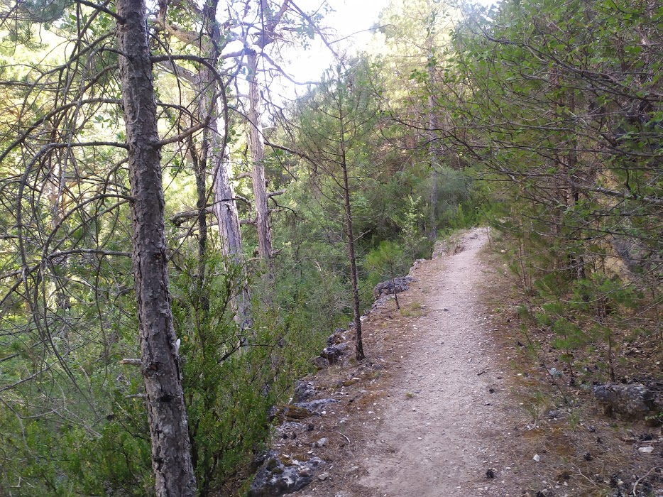
The route is signposted with few signs. blue graffiti and only in one direction, the one we should take as it is the most comfortable way to do it. Download the track of this route if you want to do it more confidently.
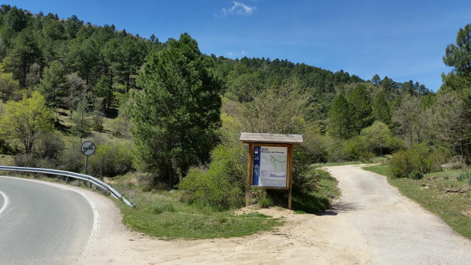
Signposting and Start of the Route
We start walking uphill from our vehicle, following the main path until we come to a crossroads. This is the best way to do the route, although we could also do it in the opposite direction, taking the path that goes off to our right practically in front of the car park.
Once at the top of the path that we have followed through a dense Scots pine forest, we see a signposted crossroads where we also see the GR-66which, from this point, takes us to the town of Iron Cave.
We continue along the route to the right, gradually entering a dense forest full of thickets that occupy the whole area, but not without first taking note of the extensive pastures where we find ourselves. This spot is known as the Hoyorredondo pitand this is where we can say that several watercourses meet, giving rise to the source of the Arroyo del HorcajoThe ravine that we are going to walk through has been carved out by this beautiful gully.
It is also worth noting that this type of fertile landscape, with abundant water and in one of the quietest areas of the Upper Tagus, is always an ideal place to stop early in the morning or late in the afternoon in the months where you can enjoy both the the bellowing of the stag, like the roaring of the fallow deerIt would not be unusual to come across some specimens emitting these spectacular sounds.

Leaving these open areas, we head towards the ravine along a narrow path that emerges to our right. It is here that we are gradually guided by the Arroyo del Horcajo stream, which flows down the ravine.
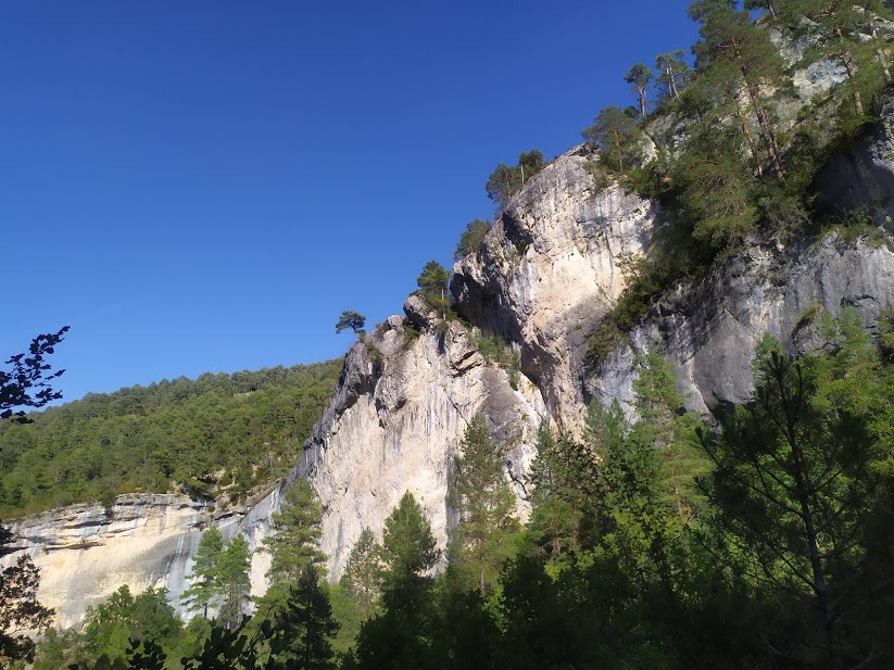
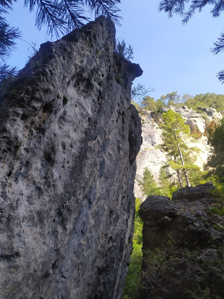
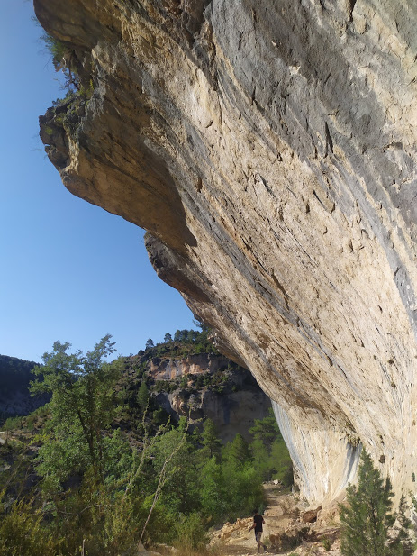
Shortly afterwards, we see how the rock walls They completely close off the view, towering immensely and boxing in the little space that remains between them. This is the most enjoyable and most worthwhile section of the route.
We walk parallel to the stream, surrounded by spectacular limestone walls, a refuge for a multitude of birds. rupicolous which find their ideal habitat in canyons as narrow as these. The stream gives us a multitude of small waterfalls that little by little shape the landscape, turning the riverbed into small, narrow canyons. tuffaceous formations constantly growing.
And, of course, all this is constantly surrounded by a dense vegetation which is of special interest, as it is one of those small pockets where you can still find more typical types of trees and shrubs. from much colder climatesThe remains of the Siberian cold climate that prevailed in these areas are a living example of this today. An example of this are the numerous lime and hazel that grow imposingly in its shady spots, as well as the yew trees that grow clinging in impossible ways to the canyon walls.
Another thing that caught our attention was that in the wet areas of the vertical rock walls flanking the stream there is vegetation of the "greasers".a kind of carnivorous plant that captures insects by trapping them in its sticky leaves, and which we have also seen in the Beteta Sickle.
As we descend we enjoy the view of the ravine and the rocky walls that delimit the course of the Tagus river, which are the ideal place to see the flight of the birds. griffon vulturesas well as some peregrine falcon in his tireless flight, or hopefully some Egyptian vulture at the time of migration.
Once we descended a steep slope where we saw an impressive natural shelter carved into the limestone rock, we can see the riverbed of the Tagus River, it is here where we made a short stop just before starting to climb, and therefore to leave this beautiful place.
Once underway, we start the ascentThe first almost vertical route, then much more bearable, takes us through a pine forest where the most outstanding feature is the abundance of large hazelnut treesThe trees, mixed with beautiful reddish-leaved maples, enjoy the shade provided by the trees that shelter them. It is here that the song of a multitude of forest birds surprises us, demonstrating the richness of these environments that are so little humanised.
We walk through the increasingly enclosed and cooler pine forest until we reach an area very close to the road. In the past, the way back was along the asphalt, but nowadays we can take a little path we find on our rightThe road then gradually climbs steadily upwards, always parallel to the road, until we reach the point where we have parked.
This section is not very difficult, but we have to take into account that all the slope we descend, we have to go back up at the end, so before we finish we still have to climb a small slope, and enjoy one of those goat trails that we love.
Remember that although it is not very long, there are no fountains where you can fill up your bottle and that this trail is currently part of the network of official footpaths of the Upper Tagus occupying the number 11.

