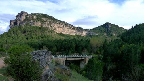
Martinete Bridge
Bridge linking the provinces of Cuenca and Guadalajara

Martinete Bridge
Dirección
4 km from Peralejos
GPS
40.59976866216, -1.9528616013083
Martinete Bridge
Located at kilometre 86 of the CM-2106, already in the municipality of Peralejos de las Truchaswe will find ourselves right on the border between the provinces of Guadalajara y Basin. If it is from the latter that we come from, the first bridge appears before us, as such, over which we can cross the already abundant Tagus River, which, upstream, a brave and cold Hoz Seca, has poured all its strength and energy into increasing its flow, is called the Puente del Martinete (Bridge of the Martinete).
<< Environment
In the area around Martinete, we can enjoy one of the most beautiful and best preserved areas of the Alto Tajo Natural Park. From the Guadalajara side of the park, we are at the foot of the Muela de Utiélin the municipality of Peralejos de las Truchas, through which we will be able to make several trails that will bring us close to several sinkholes and chasms, such as the Chaparral chasmand will take us to spectacular natural viewpoints where we will have spectacular views of the Tajo canyon, the summit of Machorro or the Horcajo Ravine.
In addition, on the rocky outcrops that we will leave at our feet, with a good eye and at the right time of the year, we will see the flight and nesting of most of the birds of prey that inhabit the park, such as the griffon vulture, the eagle owl or the Egyptian vulture.
On the same side of the bridge, we can also walk along the banks of the river Tajo to the village of Peralejos de las Truchas. Enjoying a comfortable and fresh walk accompanied by a fantastic riverside forest, we only have to go down under the bridge and look for the path that leads us towards the town.
On the Cuenca side of the Martinete bridge, we can walk through one of the most breathtaking canyons of the Alto Tajo Natural Park. It is the Barranco del Horcajo ravine routeA spectacular canyon carved out of limestone rock where we will be surprised by various botanical and geological wonders.
Finally, on the Guadalajara side, there is a dirt track that takes us parallel to the river along which we can enjoy a 9 kilometre journey between various viewpoints, until we reach another of the wonders of the Park, the Taravilla or Parra Lagoonalready in the town of Taravilla.
<< History
It never hurts to know something about the steps that history has taken in the places where we are. One of the saddest events that the locals remember took place in this place, on 16th September 1948, when the area, still divided since the Civil War between the Maquis and their persecutors, witnessed the murder by the former of four people, two civil guards and two tax collectors, who had the misfortune to cross the Martinete bridge when the Maquis were robbing everyone who passed by.
This led to the intensification of the search for those in hiding in the mountains of the provinces of Cuenca and Guadalajara, until the presence of the maquis in both provinces was eliminated. Barely a month later they caught a party, in which the only survivor collaborated, and in a few weeks it was all over.
Finally, remember that we are in an exceptional natural environment, where we can do numerous activities such as hiking, a simple walk, a swim in the river, cycling routes, canoeing down one of the most spectacular sections of the canyon carved by the Tagus. Everyone will find entertainment and enjoyment in this privileged environment that the Martinete Bridge enjoys. There are more and more visitors who decide to walk along these paths, it is normal, such beauty does not deserve to be hidden, but let us try to leave as small a footprint as possibleRespect the environment on your outings, when you return you will find it as you left it, so be as careful as possible.


