Location: Villanueva de Alcorón
Villanueva de Alcorón is located on the southern slope of the Tagus, specifically on a huge millstone cut by the Tagus and its tributary the river Guadiela at an average altitude of 1250 metres.
In the past, their greatest wealth came from the wool of their flocks of sheepIn the 20th century, however, the plant in kaolin processing employed a large part of its population.
Today, only traces of that mining industry remain, having moved to more prosperous areas.
It currently holds the title of the capital of the Mancomuniad Alto Tajo and contributes the services The municipality has basic services to the villages of the region, such as a school, pharmacy and medical centre. The municipality is bordered by towns such as Peñalén y Zaorejas of Guadalajara or Carrascosa and El Recuenco in the province of Cuenca. It sits on a karst terrain The cave is criss-crossed by numerous sinkholes and chasms, known to many cavers, perhaps the most famous of which is the Sima of Villanueva de Alcorón.
Another place of great beauty is the Pozo del SotoThe mine is a 40-metre-deep lagoon that was accidentally created when kaolin mining began in an area very close to an aquifer that eventually flooded the mine.

Pozo del Soto is the name of an old well, where today a permanent lagoon has been artificially created.
Ver más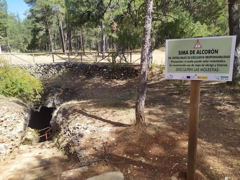
The Sima de Alcorón is a natural well 63 m deep which is easy to descend as it is equipped for visits.
Ver más
We will pass through cities of stone or enchanted cities, chasms, caves, crossing the limestone moorland covered with pines, gall oaks, junipers and junipers.
Ver más
A spectacular mature pine forest in which sits an area that gives access to the Sima de Alcorón, one of the favourites of the Natural Park.
Ver más
The Zapatilla refuge is frequented by speleologists when prospecting in the numerous chasms in the area.
Ver más
The Las Caleras de Villanueva route brings us a little closer to the traditional uses to which these mountains have been put.
Ver más